Multimodal Vision Research Laboratory
MVRL
about us

The Multimodal Vision Research Laboratory (MVRL) develops novel algorithms for image understanding and works to solve challenging problems in areas including remote sensing, image localization, and medical imaging. If you are interested in joining us, please check out our openings page for more information and a description of current open positions.
recent news
- 31 Mar 2025 : three papers accepted to CVPR workshops!
- 26 Feb 2025 : two papers accepted to CVPR, congrats to first authors Eric Xing and Aayush Dhakal!
- 09 Dec 2024 : two papers accepted to AAAI!
- 04 Nov 2024 : one paper accepted to WACV, congrats to Srikumar Sastry, Subash Khanal, Aayush Dhakal, and Adeel Ahmad!
- 03 Oct 2024 : five abstracts accepted to the AGU Fall Meeting!
- 25 Sep 2024 : one paper accepted to NeurIPS, congrats to Anindiya Sarkar, Srikumar Sastry, Aleksis Pirinen, Chongjie Zhang, and Eugene Vorobeychik!
selected recent publications
See our publications page for a complete listing. Xing E, Kolouju P, Pless R, Stylianou A, Jacobs N. 2025. ConText-CIR: Learning from Concepts in Text for Composed Image Retrieval. In: IEEE/CVF Conference on Computer Vision and Pattern Recognition (CVPR).
bibtex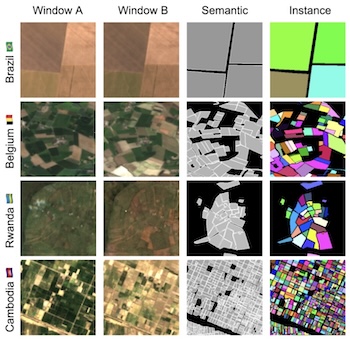 Kerner H, Chaudhari S, Ghosh A, Robinson C, Ahmad A, Choi E, Jacobs N, Holmes C, Mohr M, Dodhia R, Ferres JML, Marcus J. 2025. Fields of The World: A Machine Learning Benchmark Dataset For Global Agricultural Field Boundary Segmentation. In: Association for the Advancement of Artificial Intelligence (AAAI).
bibtex | paper | website