Multimodal Vision Research Laboratory
MVRL
research area: remote sensing and mapping
See below for a list of our publications in this area. You can see an unfiltered list of our publications or lists filtered for the following research areas: astronomical imagery and data; camera calibration; LiDAR Processing; image localization; medical and biological imaging; image motion; remote sensing and mapping; social media; video surveillance and object tracking; timelapse imaging; transportation; and outdoor webcam imagery.
publications
 Jain P, Marcos D, Ienco D, Interdonato R, Dhakal A, Jacobs N, Berchoux T. 2024. Aligning Geo-Tagged CLIP Representations and Satellite Imagery for Few-Shot Land Use Classification. In: IEEE International Geoscience and Remote Sensing Symposium (IGARSS).
bibtex-
Sarkar A, DiChristofano A, Das S, Fowler P, Jacobs N, Vorobeychik Y. 2024. Geospatial Active Search for Preventing Evictions. In: International Conference on Autonomous Agents and Multiagent Systems (AAMAS).
bibtex 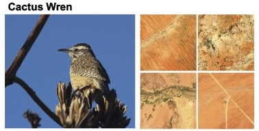 Sastry S, Khanal S, Dhakal A, Huang D, Jacobs N. 2024. BirdSat: Cross-View Contrastive Masked Autoencoders for Bird Species Classification and Mapping. In: IEEE Winter Conference on Applications of Computer Vision (WACV).
bibtex | paper | press release | linkedin | code-
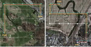
Sarkar A, Lanier M, Alfeld S, Feng J, Garnett R, Jacobs N, Vorobeychik Y. 2024. A Visual Active Search Framework for Geospatial Exploration. In: IEEE Winter Conference on Applications of Computer Vision (WACV).
bibtex | paper | press release | code -
Levering A, Marcos D, Jacobs N, Tuia D. 2024. Prompt-guided and multimodal landscape scenicness assessments with vision-language models. PLOS ONE.
bibtex  Sarkar A, Jacobs N, Vorobeychik Y. 2023. A Partially-Supervised Reinforcement Learning Framework for Visual Active Search. In: Neural Information Processing Systems (NeurIPS).
bibtex | paper | press release | code-
Liang G, Zulu J, Xing X, Jacobs N. 2023. Unveiling Roadway Hazards: Enhancing Fatal Crash Risk Estimation through Multi-Scale Satellite Imagery and Self-Supervised Cross-Matching. Journal of Selected Topics in Applied Earth Observations and Remote Sensing (JSTARS). DOI: 10.1109/JSTARS.2023.3331438.
bibtex | paper | doi -
Khanal S, Sastry S, Dhakal A, Jacobs N. 2023. Learning Tri-modal Embeddings for Zero-Shot Soundscape Mapping. In: British Machine Vision Conference (BMVC).
bibtex | paper | press release | linkedin | code -
Brodie B, Sastry S, Birge J, Pless R, Jacobs N. 2023. A Cost-sensitive Approach to Dimensionality Reduction for Multispectral Imagery. In: IEEE International Geoscience and Remote Sensing Symposium (IGARSS).
bibtex -
Sastry S, Jacobs N, Belgiu M, Maretto RV. 2023. Task Agnostic Cost Prediction Module for Semantic Labeling in Active Learning. In: IEEE International Geoscience and Remote Sensing Symposium (IGARSS).
bibtex -
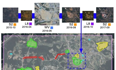
Sastry S, Dhakal A, Brodie B, Khanal S, Jacobs N. 2023. Explorations in Self-supervised Learning for Change Detection. In: IEEE International Geoscience and Remote Sensing Symposium (IGARSS).
bibtex -
Zhang Y, Rafique MU, Christie G, Jacobs N. 2023. CrossAdapt: Cross-scene Adaptation for Multi-domain Depth Estimation. In: IEEE International Geoscience and Remote Sensing Symposium (IGARSS).
bibtex -
Zhang Y, Rafique MU, Jacobs N. 2023. CrossSeg: Cross-scene Few-shot Aerial Segmentation Using Probabilistic Prototypes. In: IEEE International Geoscience and Remote Sensing Symposium (IGARSS).
bibtex -
Zhu XX, Wang Y, Kochupillai M, Werner M, Haberle M, Hoffmann EJ, Taubenbock H, Tuia D, Levering A, Jacobs N, Kruspe A, Abdulahhad K. 2022. Geoinformation Harvesting From Social Media Data: A community remote sensing approach. IEEE Geoscience and Remote Sensing Magazine 10:150–180. DOI: 10.1109/MGRS.2022.3219584.
bibtex | paper | doi -
Chen M, Hadzic A, Song W, Jacobs N. 2021. Applications of Deep Machine Learning to Highway Safety and Usage Assessment. In: Transportation Research Board Workshop (Sponsored by AED50).
bibtex -
Zhu J, Nolte AM, Jacobs N, Ye M. 2019. Incorporating Machine Learning with LiDAR for Delineating Sinkholes. In: Kentucky Water Resources Annual Symposium.
bibtex  Jacobs N, Kraft A, Rafique MU, Sharma RD. 2018. A Weakly Supervised Approach for Estimating Spatial Density Functions from High-Resolution Satellite Imagery. In: ACM SIGSPATIAL International Conference on Advances in Geographic Information Systems (ACM SIGSPATIAL). DOI: 10.1145/3274895.3274934.
bibtex | paper | doi | tweet | code-
Baltenberger R, Knochelman J, Workman S, Islam MT, Jacobs N, Griffioen J. 2013. Constructing a High-Resolution Mosaic of Kentucky Lake. In: Kentucky GIS Conference.
bibtex -
Workman S, Knochelmann J, Jacobs N, White DS, Hauer R. 2012. Registration and Visualization of Scientific Aerial Imagery at Kentucky Lake. In: Kentucky EPSCoR Conference.
bibtex -
Welty E, Pfeffer T, O’Neel S, Jacobs N. 2012. Calving Dynamics of the Columbia Glacier, AK (2000-2011 Update). In: Workshop on the Dynamics and Mass Budget of Arctic Glaciers.
bibtex